Adshead's twenty four illustrated maps of the township of Manchester : divided into municipal wards : corrected to the 1st.... (C17:70 Manchester (22))
Collection of twenty four illustrated maps, reference to the maps indicates that cross-hatching represents public buildings; heavy diagonal shading represents warehouses and places of business; light diagonal shading represents private houses.
Some sheets are hand coloured: mills and works are coloured orange; public houses, hotels and inns are coloured pink; water courses are coloured blue.
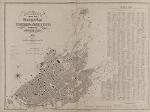
Index map (sheet 24) lists wards, street names, key buildings and the sheets on which they appear. Index map also shows 1841 and 1851 population data of the township of Manchester, borough of Manchester, and Manchester and Salford combined.
Information about this document
- Physical Location: Main Library Special Collections
- Collection: Map Collection (Flat)
- Classmark: C17:70 Manchester (22)
- Title: Adshead's twenty four illustrated maps of the township of Manchester : divided into municipal wards : corrected to the 1st. May, 1851.
- Subject(s): Manchester -- Map.; Manchester (England)
- Publisher: Adshead, Joseph, 1800-1861.
- Place of Publication: England, Manchester
- Date of Publication: 1850-1851
- Language(s): English
- Associated Person(s): Thornton, Richard
- Extent: Multi-sheet map, on 24 sheets 840 mm x 1040 mm. (some slight variation).
- Material(s): Paper
- Format: Maps
- Bibliography:Recorded in University of Manchester Library Search
Section shown in images 4 to 4
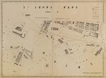
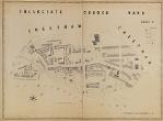
- Title: Township of Manchester no.4: St Johns Ward (part 3).
- Note(s):
Shows Castlefield, Knott Mill, River Irwell, Rochdale Canal, Bridgewater Canal and River Medlock.
Want to know more?
Under the 'More' menu you can find metadata about the item, any transcription and translation we have of the text and find out about downloading or sharing this image.
Zooming image © University of Manchester Library, All rights reserved.
- Physical Location: Main Library Special Collections
- Collection: Map Collection (Flat)
- Classmark: C17:70 Manchester (22)
- Title: Adshead's twenty four illustrated maps of the township of Manchester : divided into municipal wards : corrected to the 1st. May, 1851.
- Subject(s): Manchester -- Map.; Manchester (England)
- Publisher: Adshead, Joseph, 1800-1861.
- Place of Publication: England, Manchester
- Date of Publication: 1850-1851
- Language(s): English
- Associated Person(s): Thornton, Richard
- Extent: Multi-sheet map, on 24 sheets 840 mm x 1040 mm. (some slight variation).
- Material(s): Paper
- Format: Maps
- Bibliography:Recorded in University of Manchester Library Search
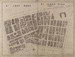
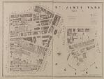
- Title: Township of Manchester no.1: St Anns Ward and St James Ward (part 1).
- Note(s):
Shows Manchester Royal Infirmary, Piccadilly, Manchester Exchange and St Ann's Square
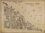
- Title: Township of Manchester no.2: St Johns Ward (part 1) Exchange Ward (part 1).
- Note(s):
Shows River Irwell and Deansgate.
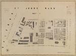
- Title: Township of Manchester no.3: St Johns Ward (part 2).
- Note(s):
Shows London and Northwestern Railway, Water Street, Liverpool Street and Quay Street.
- Title: Township of Manchester no.4: St Johns Ward (part 3).
- Note(s):
Shows Castlefield, Knott Mill, River Irwell, Rochdale Canal, Bridgewater Canal and River Medlock.
- Title: Township of Manchester no.5: St James Ward (part 2).
- Note(s):
Shows Deansgate, Peter Street, Free Trade Hall, Theatre Royal, Natural History Museum and Rochdale Canal.
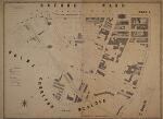
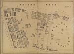
- Title: Township of Manchester no.6: Oxford Ward (part 1).
- Note(s):
Shows St Peter's Square, Oxford Street, Bridgewater Street, River Medlock and Rochdale Canal.
- Title: Township of Manchester no.7: Oxford Ward (part 2).
- Note(s):
Shows Victoria Basin and River Medlock, London Road, Sackville Street, Chorlton Street and Granby Row.
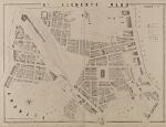
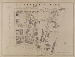
- Title: Township of Manchester no.8: St Clements Ward (part 2).
- Note(s):
Shows London Road Station, Fairfiled Street, Store Street and parts of Great Ancoats Street and Ashton Canal.
- Title: Township of Manchester no.9: St Clements Ward (part 1).
- Note(s):
Shows Stevenson Square, Newton Street, Dale Street, Great Anocats Street, London Road, Rochdale Canal and Ashton Canal.
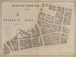
- Title: Township of Manchester no.10: Collegiate Church Ward (part 1) Exchange Ward (part 2).
- Note(s):
Shows Market Street, High Street, Lever Street, Smithfield market and Stevenson Square.
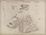
- Title: Township of Manchester no.11: Collegiate Church Ward (part 2).
- Note(s):
Shows Hunts Bank, Walkers Croft, Miller Street, River Irk, River Irwell, Manchester Cathedral, Victoria Station and Manchester Union Workhouse.
- Title: Township of Manchester no.12: Collegiate Church Ward (part 3).
- Note(s):
Shows Red Bank and River Irk.
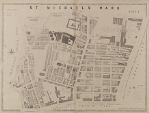
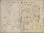
- Title: Township of Manchester no.13: St Michaels Ward (part 1).
- Note(s):
Shows Angel Street, Rochdale Road, Oldham Road, St Michael's Church, and Oldham Road Railway Station.
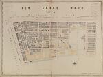
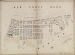
- Title: Township of Manchester no.14: New Cross Ward (part 1).
- Note(s):
Shows Great Ancoats Street, Oldham Road, Jersey Street and Rochdale Canal.
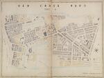
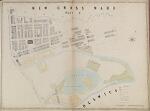
- Title: Township of Manchester no.15: New Cross Ward (part 2).
- Note(s):
Shows Great Ancoats Street, Canal Street, Mill Street, Ashton Canal and Rochdale Canal.
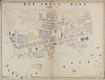
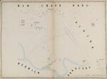
- Title: Township of Manchester no.16: New Cross Ward (part 3).
- Note(s):
Shows Great Ancoats Street, Pollard Street, River Medlock and Ashton Canal.
- Title: Township of Manchester no.17: New Cross Ward (part 4).
- Note(s):
Shows Ashton Canal, River Medlock and Medlock Dam.
- Title: Township of Manchester no.18: New Cross Ward (part 5).
- Note(s):
Shows Shooters Brook, Bradford Road, River Medlock and Ashton Canal.
- Title: Township of Manchester no.19: New Cross Ward (part 6).
- Note(s):
Shows Oldham Road, Rochdale Canal and Newton Brook.
- Title: Township of Manchester no.20: St Michaels Ward (part 2).
- Note(s):
Shows Rochdale Road, Oldham Road, River Irk, and Vauxhall Gardens, St Patrick's Chapel and Nunnery.>
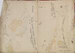
- Title: Township of Manchester no.21: St Michaels Ward (part 3).
- Note(s):
Shows Rochdale Road, Oldham Road, River Irk and Collyhurst Sandstone Quarry.
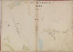
- Title: Township of Manchester no.22: St Michaels Ward (part 4).
- Note(s):
Shows Rochdale Road, Lamb Lane, Moss Brook and River Irk.
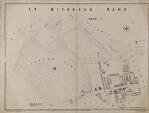
- Title: Township of Manchester no.23: St Micahels Ward (part 5).
- Note(s):
Shows Rochdale Road, Queen's Park, Manchester General Cemetry and Harpurhey.
- Title: >Township of Manchester no.24: Index map: indicating the situation of public buildings, churches, chapels, schools, highways and streets.
- Note(s):
Shows 1841 and 1851 population data of the township of Manchester, borough of Manchester, and Manchester and Salford combined.
Lists wards and the sheets on which they appear
Lists key buildings and street names and the sheets on which they appear

